The Northern Virginia Transportation Authority (NVTA)’s Route 28 Transportation Study and Project is focused on infrastructure projects that willimprove travel times and network reliability on Route 28 through Prince William County, the City of Manassas and the City of Manassas Park.
On
February 18, 2021 Prince William
County Department of Transportation
(PWC DOT) hosted a meeting to inform
residents about the Route 28 Bypass
project, including background and
current project status. The majority
of time was reserved for questions
from residents. Along with PWC DOT,
panelists from the PWC Planning
Office, Department of Public Works,
and Parks, Recreation, and Office of
Tourism were available to answer residents’
questions. DOT’s
presentation provided a general
overview of the project
including the current timeline;
Design and Engineering 2021 – 2023,
Right of Way & Utilities 2023 – 2025,
Construction 2025 – 2027.
The majority of the meetings was
devoted to resident questions and
Panel member responses. A complete
recording of the meeting, including
the DOT presentation and the
follow-on Q&A Panel, is
available at www.route28bypass.com.
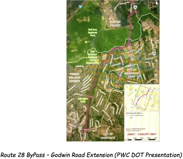
BRCWRT continues to monitor the Route 28 Bypass is project and, in collaboration with NOVA Parks and MNBP, will continue our engagement with PWC DOT to ensure potentially threatened cultural and historic sites are protected. Known historic sites within the project area include the original Mitchell’s Ford site, remnants of civil war earthworks constructed to guard Mitchell’s Ford and remnants of earthworks constructed to guard the Bull Run crossing of the Confederate Military Railroad. Additional sites north of Bull Run may be discovered as the definitive route to, and location of, the Bypass intersection with Route 28 are determined. PWC DOT plans to continue hosting information meetings (to be scheduled) and conducting resident communications and outreach on specific topics of concern to PWC residents.
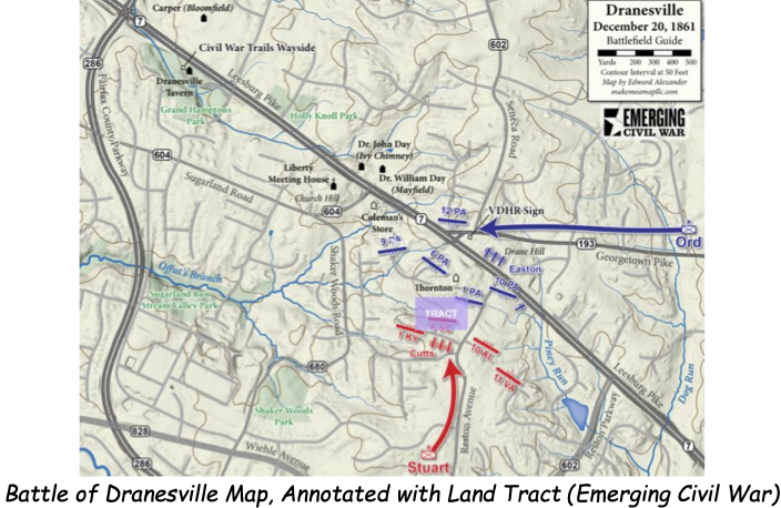
The preservation initiative to save four acres of core Dranesville Battlefield begun in September 2020 has ended unsuccessfully. Unfortunately, negotiations between the former land owner’s estate and the American Battlefield Trust (ABT) have been terminated on the mutual consent of both parties.
Though a
relatively small affair
between the units of the
Pennsylvania Reserve Volunteer
Corps under the command of
Brigadier General E.O.C Ord
and Confederate Infantry under
the command of Brigadier
General J.E.B. Stuart, the
fighting in the Battle of
Dranesville on December 20,
1861 was fierce and left a
strong impression on those who
fought here. The objective
land tract lies directly
across today’s U.S. Rt
7/Leesburg Pike from the
Dranesville Church of the
Brethren which sits on what
was in 1861 Drane Hill (see
map, below).
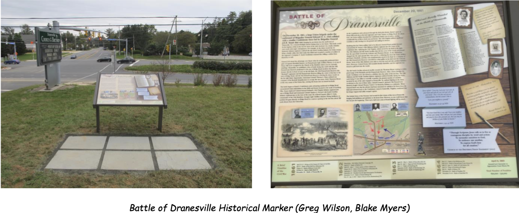
Readers
are reminded of the
Battle of Dranesville
historical marker
installed on October 10,
2020, at the Dranesville
Church of the Brethren
(11500 Leesburg Pike,
Herndon). The marker is
located on what, in
1861, was known as Drane
Hill - - which
overlooked the route of
approaching Confederate
forces under the
temporary command of
Brigadier General J.E.B.
Stuart and was the
location of three guns
from Easton’s
Battery of the
Pennsylvania Reserve Volunteer
Corps which was under
the command of Brigadier
General E.O.C. Ord.
Thank you for your continued interest in, and support of, BRCWRT’s historic preservation actions and activities. Stay strong, stay safe and stay healthy in 2021!
Blake
Myers
BRCWRT Preservation
Chair